
Share
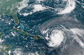
At 4:00 p.m. the centre of Hurricane Erin was located near latitude 20.0 degrees north, longitude 64.0 degrees west.
Erin is moving toward the west near 24 km/h, and this motion is expected to continue this evening. A turn toward the west-northwest is expected tonight with a decrease in forward speed, and a turn toward the north is expected to occur early next week.
On the forecast track, the centre of Erin is expected to move just north of the northern Leeward Islands, the Virgin Islands, and Puerto Rico through Sunday and pass to the east of the Turks and Caicos Islands and the southeastern Bahamas Sunday night and Monday.
Maximum sustained winds are near 260 km/h with higher gusts. Erin is a category 5 hurricane on the Saffir-Simpson Hurricane Wind Scale. Fluctuations in intensity are
expected tonight through Sunday night. A slow weakening is expected to begin on Monday.
Hurricane-force winds extend outward up to 45 km from the centre and tropical-storm-force winds extend outward up to 260 km mainly to the north of the centre.