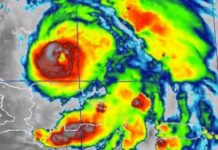
A TROPICAL STORM WARNING is being kept in effect for Jamaica as Tropical Storm Grace spreads widespread rainfall and flash flooding across the island. This means that conditions associated with a tropical storm are expected to continue across Jamaica today.
At 1:00 p.m. the centre of Tropical Storm Grace was located in the vicinity of Duncans, Trelawny, and 40 kilometres (25 miles) east of Montego Bay, Jamaica. Grace is moving towards the west near 24 km/h (15 mph), and a general westward to west-northwestward motion is expected for the next several days.
On the forecast track, the centre of Grace will continue to move near or over Jamaica’s northern coastline this afternoon and then begin moving towards the Cayman Islands this evening and tonight.
Grace is forecast to strengthen into a hurricane on Wednesday while moving farther away from Jamaica.
Doppler radar imagery confirms that eastern and central parishes have so far received most of the heavy rainfall from the tropical storm with amounts exceeding 3 inches in a number of parishes. Wing gusts reaching over 87 km/h have also been recorded in St. Andrew.
Frequent outbreaks of heavy rainfall will continue to impact the island, spreading over western parishes through this evening as Tropical Storm Grace moves westward.
Flash flooding should still be expected in low-lying and flood prone areas of mainly western and central parishes into this evening. Strong gusty winds will also continue during the next 6-12 hours.
Marine operators are reminded to remain in safe harbour until all warning messages have been lifted and sea conditions have returned to normal.


